Editor’s Note: This article is part 2 of a series. Part I was published in the Fall 2023 edition of Riverwise. Read it online @bit.ly/waterwayspartone or by going to riverwisedetroit.org and downloading the Fall 2023 edition from the sidebar.
Over the course of the past 2 years, I have traveled along more than 260 miles of Detroit’s buried waterways. This probably represents about three-quarters of the natural creeks, marshes, man-made canals, and drainage ditches that have been filled in with trash and rubble, covered by bric,k and enclosed in concrete under the city.
On this journey, I have tried to be true to the general flow of the waterways even though I cannot see the water. The creek routes shown on historic maps are now built over and their courses are blocked by freeways, railroad tracks, industrial areas, and residential neighborhoods. When faced with a barrier, l have followed the water’s example by taking the path of least resistance and meandering back to my original course on the other side of the barrier.
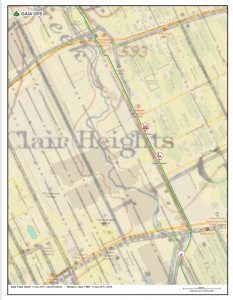
[1. Map of the route of Connor Creek now buried under the Stellantis Plant. USGS Historic 1905 1:62,500 series map layered with today’s current street map. ]
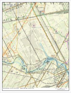
[2. Map of the route of Campbell Creek now buried under the Marathon Refinery. USGS Historic 1905 1:62,500 series map layered with today’s current street map.]
The waterways have taken me to places in the city that I would probably never otherwise have visited. I have met turkeys in The Eye and groundhogs and free roaming Pitbulls in Riverdale. I have experienced the sudden jarring transitions between gentrifying and so-called “forgotten” communities. I have marveled at the resilience of our plant relatives, sustained by the water below as they break through rarely traveled roads and sidewalks in the City Airport, Greenfield and Osborn neighborhoods among others.
The creeks also introduced me to new friends. I was honored to collaborate with LB and Andy from Ride with Purpose to clean up trash along Fox Creek at Mariner Park. After the clean up, we followed Stephans Drain, which branches off Fox Creek, approximately following Cadieux Road north before turning slightly northwest into the Ravendale community. Stephans drain could be named for S. Young, who is shown on Silas Farmer’s 1894 map of Wayne County landowners as the owner of a 60-acre lot on the north side of what is today Houston Whittier Street, just a little east of Gratiot Avenue. Members of the Young family, probably descendants of Jacob Young, who became the first Black landowner in Detroit in 1793, owned several tracts of land in the area.
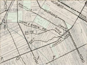
[3. Layered map of landowners and drains. – Excerpt from Wayne County and part of Oakland and Macomb, Brown, Mason L, and Silas Farmer & Co. 1894 layered with County Drains within the City of Detroit and Environs, Henry V. Herrick, Wayne County Drain Commissioner, 1961 to show the relationship between Stephans Drain, and the Young and Rhein drains and Young family land ownership (highlighted in green).]
Although the history of the creeks, their naming and relationship to colonial settlers constantly turns up fascinating little bits of information, it also feels important to me to document and engage with the ways that the creeks are still with us today. Always I look for and note the location of water and anything that relates to or feels like water. Sometimes that means permanent places like Fox Creek and Parent Creek where the water still sees daylight. There are also more ephemeral things like puddles, paddling pools, and rain, cattails, willows, geese and seagulls, and boats, murals, and garden statues. For each of these and many more I create icons to include on the map.
![]()
![]()
![]()
![]()
[4. Icon examples – puddle, Canada goose, cattails, boat]
As I continue to work on creating the map, I try to visualize the waterways in different ways. Especially I want to connect with the water and the land in ways that they might have been before colonization. One way I do this is by learning the Indigenous names for the animals, plants and habitats that have been erased by the city. I also want to care for the water, even when I cannot see it, by collecting trash along the creek routes. I use the trash to depict the creek routes and their burial under the concrete by embedding it in homemade paper.
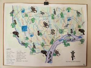
[5. Place of Many Beavers map]
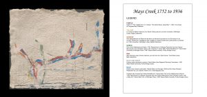
[6. Mays Creek Trash Map]
I also hope to engage you, the reader, with this project through this interactive map that invites you to find your “water address.” This map is an ongoing project. Please contact me at www.joannecouttsmaps/contact if you would like to share something for the map or join me as I continue to follow the creeks.
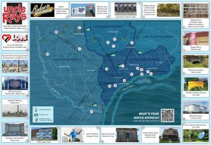
7. What’s your water address? Visit mj4detroit.map.arcgis.com to find out!
Joanne Coutts is an independent cartographer and activist whose practice is centered on the connections between our relationships with land and water, and commitment to humanitarian aid and solidarity in response to climate change. Her current projects use counter-mapping to support humanitarian aid at the so-called US/Mexico border and contribute to efforts for water rights, and rights for water, in Detroit.